Fifteen months have already passed since the Sumas Prairie was swallowed up by floodwaters, and the aftermath still lingers.
Abbotsford hops farmer Mark Topper stands in his driveway on a crisp February day. He holds his hand high on his chest to show how deep the waters were and, like others in his neighbourhood, can point to the lasting watermark along his home.
Topper is a tall man with work boots on, and there are areas even he would have had to swim, or drown. It’s a miracle no people died, and it’s no surprise when he describes post-traumatic syndrome symptoms.
An estimated 29 million cubic metres of water flowed from the Nooksack River in Washington and across the prairie, pushing around small buildings and vehicles, decimating the basements and first floors of homes and wiping out whole crops on some fields.
All that water caused major damage to roads, with 84 sites identified across the city. Many of those surround Topper’s home – a daily reminder of the most devastating moment in his life. Many of the sites were patched quickly – and poorly, he adds.
He jumps into his pickup for a drive around the block, which is known as the “lake bottom” area. His first stop is in the driveway to point over to the Barrowtown Pump Station. A bright, light-grey stretch of gravel is visible through the trees; a Band-Aid dressing, he calls it, “to make us feel better out here.”
He draws his finger across the fields, going over the timeline as the dike breached to when he finally fled his home.
“The water was just gushing over these roads that night, Nov. 16,” he says. “It was … it was pretty horrendous.”
Topper is thankful to have had the right insurance, and he and his son are at about 90 per cent through their restoration.
“We’ve been picking away at it,” he said of building back. “We were very fortunate – I won’t say lucky – but we are very fortunate we had insurance.”
What he wishes, in retrospect and if it were to happen again, is for more time to gather up belongings in those few short hours. He has been there for 27 years, has a few different businesses on the property, and that’s a lot to leave behind at the drop of a hat.
“They gave me a miraculous nine hours to get off the property before the water came,” he says, sarcasm and disbelief on his tongue. After he left, he could still see the property on a live security video feed as it slowly disappeared under the water. On day three, the power was cut. When he went back in December, he could see the water being sucked out on its way to the Fraser River, where winter waters would normally drain.
“Once they opened the flood gates, this water just boomed out of here,” he says, “Which is what it was designed to do.”
Some areas were hit worse than others, where water rushed both in and out of the former Sumas Lake bed. The irrigation system was designed 100 years ago, without a full understanding of the importance of Sumas Lake for drainage of the nearby mountains.
“Look at this corner falling apart,” he says at Marion and No. 4 Road.
He carries down Marion Road as he talks, and he points out the uneven pavement that barely covers one lane, and soft edges that slip into sloughs. It makes for a roughshod ride even in a large truck, he points out. And then he points out what’s missing, which is any sort of signage to let drivers know the poor conditions of the roads.
“Here’s another patch to be repaired,” he says, slowing down. “Nice and smooth. Mhm.”
The story is the same on South Parallel Road. While some warnings are visible, he notes that they were put there by residents. A few plastic posts are placed where the shoulder sloughs off, but they are old and faded instead of fluorescent.
Other roads are no better, and some detritus from the floodwaters still litters the ditches throughout. There are tires, farming implements, industrial plastics.
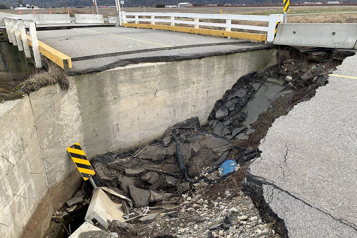
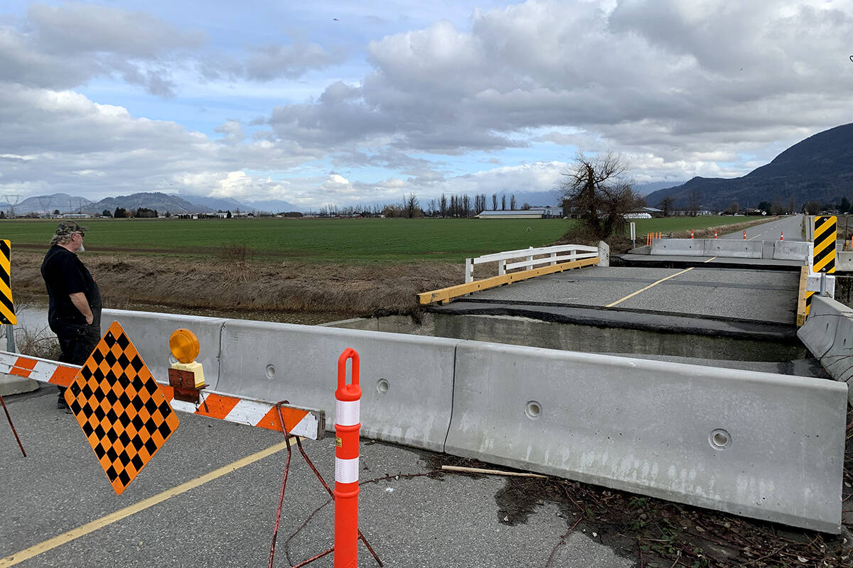
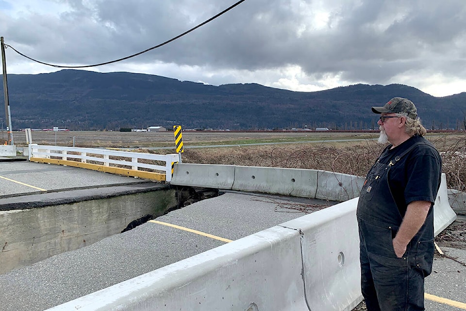
Topper pulls onto No. 4 Road and stops at the Vedder Canal. There is no going forward. The bridge is still defunct, with two huge gashes that make passage impossible.
This is Topper’s biggest concern. This is what has pushed him to ask the city for answers, then the provincial government, and then the media.
“These bridges are all outdated as it is,” he says, wondering why this one has been left so long when other projects such as the Mt. Lehman roundabout got priority. “The provincial government and the federal government did shove a lot of money this way.”
READ MORE: Sumas Prairie flood lawsuit continues to move toward class action
No. 4 Road is a main connector for summer day trippers heading from Abbotsford to Cultus Lake, and a common alternate route when the highway is jammed, which is often.
But there are no detour signs. No closed road signs. Google doesn’t alert drivers to the closed bridge, which is marked off with caution barriers.
The sort of sister bridge across the canal up at No. 5 Road is open, but that’s a more narrow road. Topper is dreading the summer traffic and potential crashes on the narrow roads.
The city says they are waiting for warmer weather to further fix the roads in the Sumas Prairie, and that the immediate fixes that took place were temporary.
“For the bridge at No.4 Road,” a city representative said, “we have an engineered design for the required repairs and are working through the required environmental works documentation to submit for the Water Sustainability Act (WSA) permitting, including working with local First Nations, which must be approved before we can proceed with these works.”
That’s what Topper was told, too, but he’s not sure how other fixes were able to be pushed through instead of this bridge.
The city has told The News that the design package they are working on includes repairs at several bridges across the prairie.
“We hope to have all permitting in place to be able to complete the works in this year’s fish window, which is typically August through to the end of September,” the representative said.
Mayor Ross Siemens said in a recent interview that they also have to take into account the need for proper irrigation at that time.
Topper looks around the prairie from the destroyed bridge. He acknowledges that a lot of work has been done, some by the city and a lot by volunteers and residents.
As he turns into his property again, more memories come back. This happens every time, he says.
“Every time I pull in the driveway I think to myself, ‘I just can’t imagine the water being this high.’ It was the perfect storm.”
READ MORE: Mini documentary shows impact of 2021 floods on Sumas Prairie farmers
@CHWKcommunity
jessica.peters@abbynews.com
Like us on Facebook and follow us on Twitter.