British Columbia is prepared to use a national emergency alert system ahead of what could be the most intense rainfall since a storm two weeks ago devastated communities and destroyed critical infrastructure, the government announced on Sunday.
Public Safety Minister Mike Farnworth announced plans to use the Alert Ready system during a briefing on the ongoing storm series, which prompted new evacuation orders and saw a major river breached its banks and threaten parts of Abbotsford, B.C. on Sunday.
The second in a series of atmospheric rivers moved in Saturday and was still dumping rain in some areas 24 hours later, while a third and possibly more severe storm is forecast to arrive on the southern coast on Tuesday.
“We’re in the middle of one of the most intense series of storms that we have seen along coastal B.C.,” Farnworth said.
“More heavy rains mean people on the north, central, south coast, on Vancouver Island, in Abbotsford and the Sumas Prairie are facing an extremely volatile situation. Once again, it’s time to be ready.”
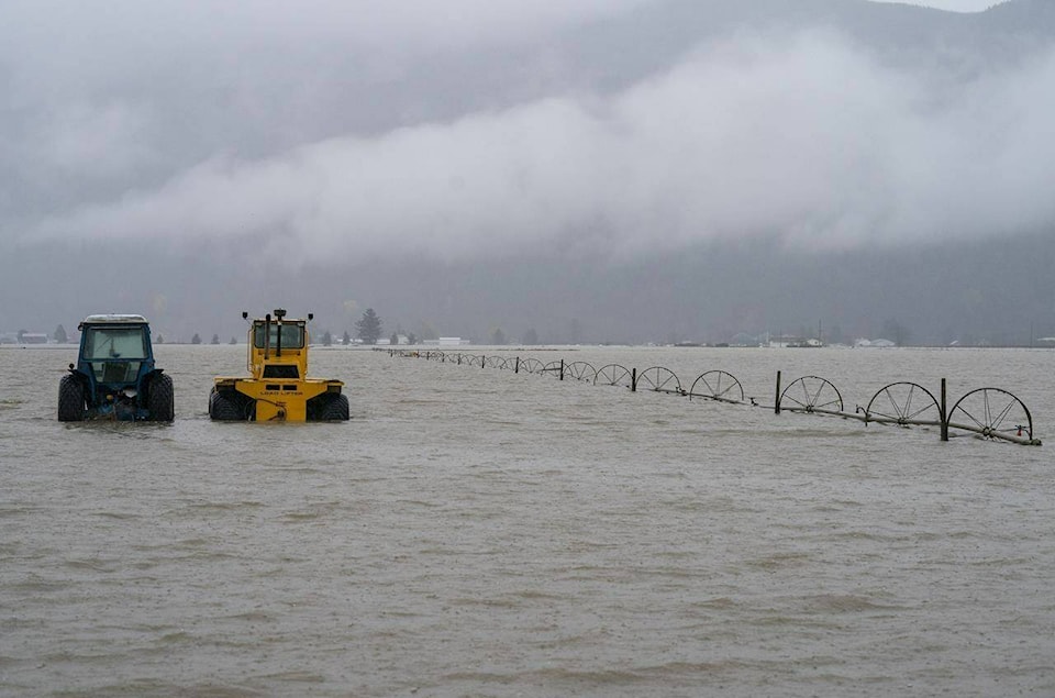
New evacuation orders were issued for 56 properties in the Petit Creek-Spius Creek area west of Merritt, B.C. and for a portion of the Huntingdon area of Abbotsford, B.C. Later, Abbotsford Mayor Henry Braun announced the Nooksack River south of the U.S. border had breached its banks Sunday afternoon and the flood waters were on their way to Sumas Prairie.
Alert Ready is a Canada-wide system that allows government officials to issue public safety alerts through major television and radio broadcasters, as well as compatible wireless devices.
The system has been available since 2018, but B.C. has faced criticism for not using it to warn residents of deadly disasters this year, including the wildfire that all but destroyed Lytton, B.C., and the heat dome that led to hundreds of deaths.
“B.C.’s emergency warning systems are not meeting the challenges of today’s natural disasters. That’s on this government,” BC Liberal MLA Todd Stone, who represents Kamloops-South Thompson, said during Question Period on Nov. 18.
“All other provinces are using the Alert Ready system. They’re using it for tornadoes. They’re using it for wildfires. They’re using it for a range of other natural disasters. We’re not using it here.”
Farnworth said Sunday provincial officials are in contact with local governments, First Nations and emergency staff in areas where forecasts predict the worst impacts mid-week. B.C. is prepared to support them with the Alert Ready system should they determine there is a threat to life or public safety, he said.
“Local governments are the experts on the ground and emergency managers at the local and provincial levels will continue to closely co-ordinate through the days ahead,” he said.
Officials warned that the next storm could reach intensities similar to those seen in the downpour that destroyed highways, flooded communities and prompted mass evacuations two weeks ago. The next storm is due to strike the central coast Monday before moving south, with the greatest impacts expected on Tuesday and Wednesday.
Armel Castellan of Environment and Climate Change Canada said there is a lot of uncertainty at this stage, and while meteorologists hope the impacts remain as low as possible, they are urging maximum caution, vigilance and readiness for a “very strong storm and swell.”
Farnworth urged residents of southwestern B.C. to avoid all non-essential travel in the days ahead.
Environment Canada lifted weather warnings for many parts of the province Sunday as the second storm began to pass, however it warned snowmelt was adding to the runoff and risk of flooding thanks to strong warming that forced the freezing levels well above mountaintops.
The River Forecast Centre issued a new flood warning for the Coquihalla River. The Regional District of Okanagan Similkameen said any residents who lingered in the Tulameen areas since an evacuation order took effect two weeks ago should leave immediately due to rising water levels.
In Abbotsford, the mayor said the region was bracing for expected flooding from the Nooksack River in Washington state.
Braun said Abbotsford’s dikes were in better shape Sunday than they had been ahead of the disastrous flooding two weeks ago thanks to repairs and added height.
“What we don’t know is was there any damage done to the integrity of the dike that we can’t see,” Braun said during a news conference.
“We have done what we can do and we are ready, as ready as we can be, for the event that is about to unfold.”
The Transportation Ministry said the threat of flooding forced the closure of Highway 1 between Abbotsford and Chilliwack Sunday evening.
Transportation Minister Rob Fleming said crews were assessing “minor” damage elsewhere in the province along stretches of highways 1, 3 and 99 that were closed as a precaution ahead of the weekend storm. The damage included some landslides, fallen trees and other debris, he said.
Flooding forced the closure of a 4.8 kilometre stretch of Highway 7 in Maple Ridge overnight and Fleming recommended monitoring Drive BC for updates.
The Red Cross has distributed $2.25 million to evacuees across the province who are eligible for $2,000 to help cover emergency costs, the government said.
— By Amy Smart, The Canadian Press
RELATED: More Abbotsford evacuations as crews try to hold back Sumas River floodwaters
RELATED: Upcoming 3rd atmospheric river could be worst since 1st B.C storm 2 weeks ago: Farnworth