A small earthquake that rattled buildings and woke some Abbotsford residents is a reminder that the ground beneath the Fraser Valley has the potential to shift at a moment’s notice.
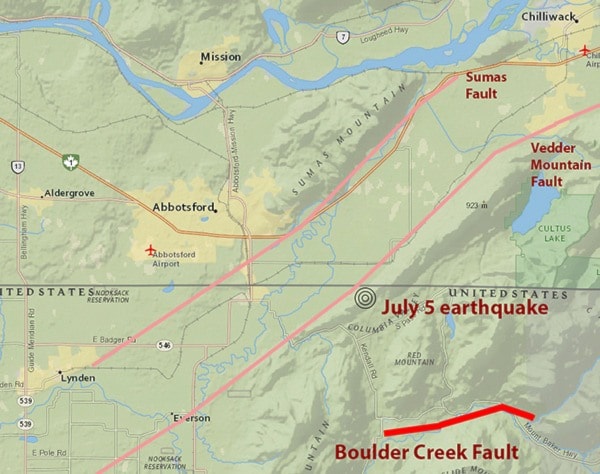
The quake, measuring 3.3 on the Richter Scale, took place around 12:45 a.m. Sunday. The tremor occurred 10 kilometres below ground and was centred about seven kilometres southeast of the city, just south of the U.S.-Canada border, according to the U.S. Geological Survey.
Many residents wrote on Facebook that they were woken by a large bang, with some reporting substantial shaking. Many others, though, said they didn’t feel anything.
While no damage was reported and small earthquakes are not uncommon in Western British Columbia, Sunday’s tremor hints at the challenges posed by the Fraser Valley’s unique geology.
The danger posed by the Cascadia Subduction zone lurking off the coast of Vancouver Island is well-known. A massive potential earthquake – “The Big One” – measuring in excess of 8.0 on the Richter Scale, would likely do billions of dollars of damage in the Lower Mainland and on Vancouver Island.
Abbotsford’s distance from the quake means that the low-frequency rolling waves from a major tremor could pose a danger to larger buildings in the Fraser Valley, according to Garry Rogers, an earthquake scientist with the Geological Survey of Canada.
Although smaller buildings are less at risk, they could still sustain damage, depending on how they were built.
Then there are the local faults.
In 2008, a short, jagged 11-kilometre line was added to a United States Geological Survey (USGS) map. It’s positioned 17 kilometres southeast of the city, and could deliver a jolt to Abbotsford residents.
The line represents what is known as the Boulder Creek Fault, which begins near Kendall, Wash., and runs roughly parallel to the Mount Baker Highway. The USGS says the fault is capable of a 6.8-magnitude earthquake and has been active.
But although a 6.8-magnitude earthquake near Olympia, Wash. in 2001 killed one person, injured around 400, and caused substantial damage, Rogers said the Boulder Creek Fault isn’t a major danger to this area.
That, he said, is because the fault lies within just one kilometre of the surface, compared to a depth of 50 kilometres for the Olympia quake. The shallow depth means the strength of the shaking will decrease rapidly as distance increases from the quake’s epicentre.
“It’s proximity, proximity, proximity,” Rogers said, noting a potential earthquake has been modelled on the area.
Such an earthquake would rank six on the Mercalli intensity scale, with strong perceived shaking but light damage.
The fault isn’t the only one in the area. On each side of the Sumas Prairie, two parallel faults lie below the edges of Sumas and Vedder mountains. They run through the eastern portion of Abbotsford before crossing the border in a southeasterly direction.
The faults were the subject of a 2000 paper by three Western Washington University professors who wrote the faults “pose serious seismic hazards to the region,” and the paper has been cited in reports prepared for municipal and county governments.
The faults are not shown on the U.S. Geological Survey’s (USGS) seismic hazard maps of the region, and Rogers said no active faults have been recorded on the Canadian side of the border.
Most don't have earthquake insurance
Despite living on some of Canada’s most seismically active areas, earthquake insurance can be a hard sell for British Columbians.
Home insurance policies do not automatically protect against damage from quakes. But while additional earthquake coverage can be purchased, a 2014 poll suggests many British Columbians forego it, either out of a lack of knowledge, or because they don’t think a quake is likely to strike their area.
In response to a question on The News’ Facebook page, residents cited concerns about large deductibles and even the solvency of the insurers.
Some of those concerns are more valid than others.
While any single year carries a relatively small risk of an earthquake, when a tremor does strike, it could wipe out billions of dollars worth of property.
The huge scale of such a disaster means deductibles can be large. Clay Germain, the president of the Insurance Brokers Association of British Columbia, said deductibles range between five and 25 per cent of the cost to replace or repair damaged property.
They vary substantially depending on the risk to the local area. Germain said insurers categorize areas – often down to the postal code – with higher-risk areas like Richmond requiring larger deductibles.
Abbotsford, he said, is “on the mid- to lower end compared to some of the higher risk areas of the Lower Mainland.”
One insurer gives each location a rating on a scale of one to six, where Richmond is a one and Abbotsford rates a three or a four, depending on the postal code. Deductibles here, Germain said, are in the 10 per cent range.
He also noted that policies exist that essentially insure against the cost of paying the deductible for one’s earthquake insurance.
The ability of insurers to pay out if a big earthquake strikes, meanwhile, has not only been of concern to potential customers. In 2012, Canada’s Office of the Superintendent of Financial Institutions required insurers to have more money on hand in case of a large earthquake.
Awareness is perhaps the biggest challenge, though. The 2014 Insurance Bureau of Canada reported that 71 per cent of respondents said they would rely on insurance to cover rebuilding costs, despite most not having earthquake insurance.